Text and photos from National Audubon Society IBA Database Site Profile
Owens River Site Description
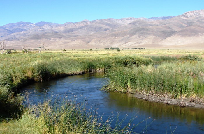
Draining the eastern Sierras from near Bishop south to Owens Lake, the Owens River is the northernmost of the four desert rivers of California. It supports an extensive network of riparian woodland, freshwater marsh and alkali meadow habitats at the eastern base of the Sierra Nevada. In the early 1900’s, Owens River was rerouted from the eastern Sierra Nevada into the Los Angeles Aqueduct to support the agricultural expansion of the Los Angeles area. As a result, Owens River was transformed and degraded. The flow of the lower Owens (from Owens Lake to about 60 miles north) was reduced drastically and its water held in large reservoirs along Highway 395, controlled by the Los Angeles Dept. of Water and Power (LADWP). The floor of the Owens Valley, once a lush valley with swamps and orchards, was transformed into comparatively arid ranchland with small stringers of grazed riparian vegetation. Nearly all the habitat is still in private ownership or controlled by the DWP (and leased to ranchers) along the main stem of the Owens River and associated tributaries. Key areas include (north to south):
- Fish Slough Area (6,400 acres of freshwater marsh, alkali meadow and limited riparian habitat, jointly-owned by BLM, DFG, DWP/Private; just north of Bishop)
- Warren and Klondike Lakes (DWP with public access for fishing and boating; large impoundments just north of Big Pine)
- Baker Meadow (DWP/Private; excellent riparian and meadow habitat just west of Big Pine)
- Tinemaha Reservoir Area (DWP with public access for fishing; c. 10 miles south of Big Pine; includes Fish Springs, a large area of marshes and meadows, and mature riparian woodland along the Owens River above and below the reservoir)
- Billy Lake (DWP with public access for fishing) Large freshwater marsh just east of Independence)
- Hogback Creek (DWP/Private; riparian habitat west of Highway 395 c. 5 miles north of Lone Pine)
- Edward’s Field (DWP/Private; Mature riparian woodland and meadow in town of Lone Pine)
Conservation Issues
The principle challenge to conserving birds within this IBA involves their management on private lands. Fortunately, recent (c. 2000) changes within the LADWP have resulted in a major shift in management philosophy of their holdings, which hold the lion’s share of sensitive bird species in the Owens Valley. The “Lower Owens River Project” (LADWP), scheduled to begin in 2003, should restore flow to the lowermost 60 miles of river (and fence large areas from cattle), including 300 acres of wetlands at the delta of Owens Lake (G. Coufal, LADWP, in litt.). Their recent efforts to increase surface water flows along the Owens River and to protect riparian resources from cattle grazing (the main economic force here aside from tourism) should be supported. Millions of people drive along Highway 395 each year to world-famous skiing and fishing areas, and any conservation effort here has great potential to meet a large, diverse audience.
Ornithological Summary
The riparian habitats associated Owens River are already among the most extensive in the state, and with continued commitment by the LADWP to improve their habitat value for birds, will provide essential habitat into the future. The northern end of the valley has been found to support two riparian breeders widely extirpated as nesters from central and southern California: Bank Swallow and Willow Flycatcher, which persist locally southwest of Fish Slough. Baker Meadow has emerged as one of the consistent spots for Yellow-billed Cuckoo in the state, with up to 9 birds summering recently at Baker Meadow and scattered pairs and singles elsewhere. Virtually all of the riparian birds of this IBA may be found commonly at Baker Meadow (e.g. Yellow-breasted Chat, Summer Tanager). Summer Tanager nears the northern limit of its California range at Baker Meadow, breeding commonly in remnant patches of mature riparian woodland. Swainson’s Hawk breed throughout in massive Fremont Cottonwoods on the valley floor, in what is probably the stronghold of their population in Central and southern California. The freshwater marsh habitat supports large numbers of rails, as well as local pockets of summering Least Bittern (e.g. Fish Slough, Billy Lake). At Tinemaha Reservoir, Osprey bred on platforms and winter waterfowl concentrations here are by far the largest in the IBA. Klondike and Warren Lakes also see heavy use by waterfowl. Local water conditions (e.g. draw-downs that expose mudflats) can make wet areas attractive to shorebirds in migration, with 1000+ shorebirds during a recent spring survey at Tinemaha Reservoir (D. Shuford, unpubl. data). This IBA also supports several species typical of Great Basin meadows, including summering Short-eared Owl particularly along the Owens River southeast of Bishop. Burrowing Owl, nearing extirpation from Owens Valley, may persist just south of Independence.
Help us learn more about the birds at this IBA! Enter your birding data online at California eBird! (http://ebird.org/california/)
Click here for a bar chart of eBird observations on the Owens River.


